Seismic studies
With a detailed map of the tectonics of the Greater Caucasus, it should be possible to predict earthquakes. By Pierre-Yves Frei
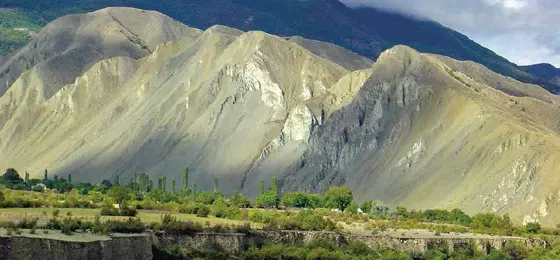
The peaks of the Greater Caucasus are of rare beauty. They also contain the highest summits in Europe. Mount Elbrus (5,642m) is considerably taller than Mont Blanc, as is Mount Kazbek (5,033m). But the region is also known for its instability: not only political instability – given the many regional tensions and the relative difficulty in crossing borders – but also seismic instability. Some areas of the Caucasus Mountains are prone to frequent, violent earthquakes. These tremors have brought with them uplift in several parts of the range, greater even than in the Alps."Our work is to understand better what is happening in the region: what is the exact result of collisions between the Arabian and Eurasian tectonic plates, how seismicity is related to the complex system of major fault lines, how these fault lines have influenced the topography and of course how the various tectonic elements organised themselves during the fold and thrust process".
It’s been 12 years since the first scientific expedition of Jon Mosar, a professor of geology at the University of Fribourg. That was to Azerbaijan. "Today our team is made up of Azerbaijanis, Georgians and Russians. We have a common interest in the geology of this region which prevails over any political disputes. Thanks to this Scopes project, we can apply our measure of support to research, cruelly in need of funding in these countries. In this way we help to recruit young scientists".
Fifteen million years young
Like the Alps, the Caucasus Mountains are geologically young, dating back some 5–15 million years. The Alps, however, emerged following the subduction of the African plate under the Eurasian plate, whereas the Caucasus Mountains are the result of a collision with the Arabian plate. Another difference is that, while the Lesser Caucasus were a direct result of this subduction, the formation of the Greater Caucasus also involved the closure of a huge sedimentary basin more than one hundred million years old. The geologists are particularly interested in this tectonic unit. They are trying to map what happened to it and how it become part of the range, so as to understand better how the range itself formed.
(From "Horizons" no. 102, September 2014)