Computing the bird’s eye view
Innovative computer models are allowing us to make more of satellite images. By Anton Vos
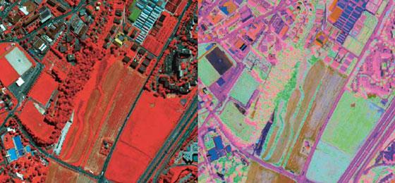
(From "Horizons" no. 104, March 2015)The use of satellite images of the Earth is becoming more and more popular amongst scientists in a large number of fields such as agriculture, urbanism, forestry, water quality, natural disasters etc. Furthermore, the maps that are created from these images are often published in the media and play an important role in decision-making processes, particularly when it comes to land management. Problems arise, however, when the technical limits of automated computer techniques hold back the extraction of useful information contained in images. A good example of this is comparing two different shots of the same location only to find that the images – taken at two different points in time – vary in their quality, colours or exposure, sometimes to a considerable degree.
These technical limits have been pushed back by Devis Tuia, a professor at the University of Zurich and at EPFL. One of his models has been successfully used to adapt an analysis program for urban structures based on satellite photos. The original program was developed for a specific city but has since been applied to a different city. Conclusive tests have been carried out in Lausanne and Zurich. In a different project, Tuia has developed a system that allows the comparison of images of the same location but which were taken using different apparatus (satellites, drones or aeroplanes) and therefore do not have the same technical characteristics in terms of spatial and spectral resolutions. Tests were also carried out as part of forestry studies aiming to measure variations in the quantities of different tree species over time.
“The human brain can compensate naturally for differences in the lighting of the same object and can therefore compare two images with different characteristics”, Tuia says. “The idea is to teach these kinds of abilities to computers”.
Artificial intelligence
Tuia has managed to do this by using artificial intelligence tools that mean computers learn to adapt to new environments. One step in this process is the ‘normalisation’ of images, i.e., suppressing all of the variations caused by the overriding conditions at the time the image was taken and which are not of interest to user. This leaves behind only the useful elements.
“Studies into the quality of crops in a region, for example, can therefore be done using aerial photographs”, he says. “It is actually possible to gather important information on a specific crop by analysing the way in which infrared light is reflected by plants. This does, however, involve first having collected soil samples. But then, if the user wishes to obtain the same information five years later, a model such as the one I have developed means there will be no need to repeat the groundwork, and this can save a lot of time and money”.
Anton Vos is a science journalist, working chiefly for the University of Geneva.