Switzerland needs nationwide soil mapping
To use soil sustainably calls for detailed information about its properties. However, this is lacking for large areas of Switzerland. The National Research Programme “Sustainable Use of Soil as a Resource” (NRP 68) is proposing a “Swiss soil information platform” and showing how soil mapping can be expedited by using digital methods.
Soil information describes the structure and properties of soil. Thorough nationwide information is vital in order to better accommodate the various demands put on soil, particularly with regard to sustainable food production, drinking water treatment and spatial planning.
Whereas comprehensive data on water and air has been collected and appropriate monitoring networks operated for decades, Switzerland lacks nationwide information on the state of its soil. The country is therefore unique within Europe, despite the pressure on the soil.
The National Service Centre for Soil Mapping was disbanded in 1996, and its role was passed to the cantons. Only a few cantons have been able to fill the existing data gaps since then. Today, soil information of sufficient quality and coverage has been collected for just 10 to 15 per cent of agricultural land. Yet this lack of standardised nationwide soil information is one fundamental reason why soil is scarcely considered in many policy areas and decision-making processes.
Map valuable farmland first
In the NRP 68 thematic synthesis report “Swiss soil information platform”, the authors are outlining a way in which soil data collection can be accelerated and coordinated across the country. The key part of the platform involves supplementing conventional soil data collection in the field with digital soil mapping techniques and a modified procedure that makes it possible to map larger areas than before. The aim here is to make increasing use of automated procedures, both for data collection and for the analysis of soil samples.
The authors propose mapping first of all those areas that are most important for the sustainable use and protection of the soil, such as high-quality crop rotation areas near settlements. According to Armin Keller of Agroscope, this phased approach should also contribute to optimal resource usage and safeguard the cross-generational transfer of knowledge. A clear, long-term programme of this type would also give the sector the confidence it needs to make the necessary investment in new technology.
Besides optimised, accelerated data collection, it is also necessary to improve the way soil information is processed, coordinated and accessed. Although a comparable platform currently exists in the form of the NABODAT soil information system, the national soil monitoring, it is customised for the needs of the federal and cantonal enforcement authorities, and can only be accessed by those bodies. The authors recommend that access to soil information and associated meta-information be given to a broader audience, for example planning offices and farmers.
Investment with a payback
“Data collection and the creation of this soil information platform is a forward-looking investment that will span the next twenty years,” explains Armin Keller. It will cost an estimated 15–25 million Swiss francs per year, primarily to pay for the necessary infrastructure and for mapping by private engineering offices.
The authors use ten examples to illustrate how nationwide soil mapping creates added value. Thanks to improved soil information, the cost of drinking water treatment alone can be reduced by 10–15 per cent or 7–10 million francs per year. This information will also help to reduce soil compaction and erosion, and optimise the use of fertilisers in farming. Very conservative assumptions for the ten examples indicate that the benefits of improved soil information across Switzerland will amount to between 55 and 132 million francs per year.
“Every franc invested in soil mapping will therefore be repaid many times over, to the benefit of society and future generations,” stresses Armin Keller.
Keller Armin, Franzen Julia, Knüsel Paul, Papritz Andreas, Zürrer Martin (2018): Swiss Soil Information Platform (BIP-CH). Thematic synthesis report TS4 for the National Research Programme “Sustainable Use of Soil as a Resource” (NRP 68), Bern.
ISBN:
-34-3 (German); ISBN
-35-0 (French)
Obtainable from:www.nrp68.chand
Contact
National Research Programme "Sustainable Use of Soil as a Resource" (NRP 68)
NRP 68 is laying the foundations for the sustainable use of soil in Switzerland. This requires both the ecological and the economic benefits of soil to be considered. The concept of ecosystem services provides an opportunity to link soil functions and their value to human well-being.
This is the first of three press releases that NRP 68 is publishing on its thematic synthesis reports. The second release, “Keeping soil fit”, will be issued on 26 April 2018, and the third about “Maintaining valuable soils” on 3 May 2018.
Links
- Thematic synthesis report “Swiss Soil Information Platform” (in German) (PDF)
- Graphics (all graphics in German or French only) (PDF) (PDF)
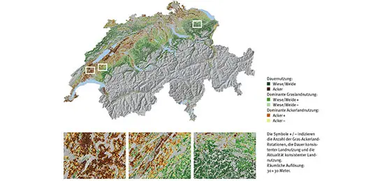
- Cover photo: Land use classes for agricultural land in the Swiss Plateau from 2000 to 2015 (JPEG) (JPEG)
- Graphic 1: Soil mapping in Switzerland since the 1950s (JPEG) (JPEG)
- Graphic 2: Added value of soil mapping for ten selected topics (JPEG) (JPEG)
© Armin Keller, Agroscope